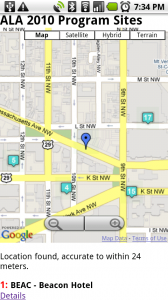
 As I’ve mentioned before, summer is often my most productive time of the year at work. Especially when it comes to special projects. Last summer I focused on developing a mobile site, and this summer I’m looking into the potential of geolocation in websites. My ultimate goal is to mash up GIS data with our special collections and a user’s current position. I’m not there yet. But I do have a system up and running that might provide some utility at ALA in DC next week!
Here’s the site, designed for mobile devices: http://www.hiddenpeanuts.com/ala I pulled the 18 program sites out of ALA’s list of programs, and plotted them on a google map. Then it plots the user on the same map via the phone’s GPS signal. I’ve tested it on an iPhone and Android phones, but I think it should work on webkit-based Blackberries and maybe even the Palm Pre too. (Update: Turns out the Pre doesn’t support geolocation via javascript. boo, indeed!) I’d love feedback on how those devices work (or don’t).
Obviously the site won’t show you much unless you happen to be in DC while loading it up 🙂 So here’s a demo which simulates the user being in DC.
I’m very interested in any feedback on this system. I know that the interface needs (a lot of) work, but this is as good as I’m likely to have time for before ALA. I’m also open to suggestions on what details about each location would be helpful to have on the mobile site. For now it’s just address and phone number.